The Etzanoa Conservancy is excited to announce a new logo in conjunction with rebranding.
In addition to the logo, a new website is at https://etzanoa.net. The objective of the rebranding was to create a comprehensive image compatible with the mission, vision, and growth of the conservancy.
Mark Dykes of Crowley County Community College and his students collaborated to formulate logo ideas for the Etzanoa Conservancy Board. Through this process, Dykes created a logo the board felt was aligned with the values of the Conservancy. Its nuanced reflection of the long history of Etzanoa can be seen in every line.
The colors are similar to the previous logo with the addition of an orange tone to represent the grasses on the Great Plains.
Dykes modeled the lettering of the logo after a 1605 copy of Don Quixote as a nod to the Spanish’s visit in 1601.
Key components of this logo include the “O” containing the portion of the Miguel Map, dictated by an indigenous man, was the clue to the rediscovery of the location of Etzanoa in Arkansas City, KS. The section of the map depicted has lines representing rivers and trails as well as two ovoid shapes indicating places of inhabitance. This is Etzanoa.
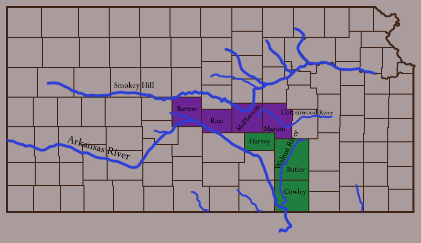
The theory of local historians and amateur archaeologists that central Kansas, and particularly the vicinity of Lyons, is the Kingdom of Quivira visited by Coronado in 1541 has been given its first nod of approval by the Smithsonian Institution1. It comes in an interim report to the society by Dr. Waldo R. Wedel, assistant curator in the division of archaeology who made an investigation into numerous Indian village remains in Rice and Cowley counties in the summer of 1940. In summarizing his observations in the field and research into Coronado history, Dr. Wedel said: Scattered throughout a wide area in central and southern Kansas, chiefly in the Arkansas basin but extending also into the Smoky Hill and upper Cottonwood drainages, are numerous aboriginal village sites. Preliminary archaeological investigations show that these were the habitat of a widespread and numerous semisedentary people practicing maize-bean-squash horticulture, as well as hunting and gathering. There is a striking uniformity in the pottery and other cultural remains from sites in Rice, McPherson, Marion, Butler and Cowley counties2. “The discovery of chain mail fragments, glass beads, an iron axe blade, etc., indicate that the sites were inhabited into or during a very early period of white contac[t]; turquoise, [glaze-paint?] sherds and obsidian are evidences of trade relations with Puebloan groups in the Rio Grande area. Moreover glaze-paint sherds from widely separated sites in Rice and Cowley counties have been identi- Turn to Page Three
Says Cowley Quivira Area
Continued From Page One fied with wares produced on the Rio Grande between circa 1525 and 1650. “As I view the archaeological evidence and its geographical setting the conviction is strong that the Quivira of the sixteenth-and early seventeenth-century Spanish documents and the central-Kansas arch[a]eological sites were the habitat of one and the same people. I cheerfully admit that the final word on the routes3 of Coronado and Onate has yet to be written. Meanwhile, and until convincing evidence to the contrary is adduced, including archaeological and ethnological4 as well as documentary data, I am of the opinion:
“(1) That Coronado’s entrada into the province of Quivira probably took place in the present Rice-McPherson county locality.
(2) That Onate’s visit to Quivira 60 years later possibly took place on the Walnut river near the present Arkansas City, Kansas.
(3) That while the exact limits of Quivira in Kansas cannot now be set up, the heart of the province lay north and east of the Arkansas and south of the Smoky Hill, extending from Rice, or possibly Barton, county east through McPherson and Marion counties, thence south through Harvey, Butler and Cowley counties, to or beyond the Kansas-Oklahoma state boundary.”
Dr. Wedel is a native of Newton, Kas. Some of this earlier work included research into the Pawnee Indian culture of northern Kansas and Nebraska, which is believed to be closely related to the Wichita, or Quiviran. He has also examined the well-known Whiteford Indian burial excavations near Salina and in a footnote in the booklet just published expressed this opinion: “Contrary to some local views, I see no evidence whatever for regarding the Whiteford burial pits east of Salina as belonging to the manifestations under discussion. The associated pottery types and earth-lodge dwellings pretty definitely align these burial with a different and earlier people probably more closely related to the pre-historic Upper Republican horizon.” Dr. Wedel and his Smithsonian Institution party spent several weeks in the Arkansas City area during the summer of 1940, opening Indian mounds on the Country club grounds and in the Walnut valley just above the city.